Miranda
The Voyager 2 Mission
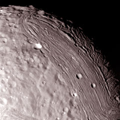
 Image [A] was taken with high resolution images with a resolution of about 0.6 km per line pair. (Credit: Smith) |
 This image was combined from one wide-angle and eight narrow angle images. The trapezoidal region (about 200 km) towards the south pole to center of the mosaic, also showing the outer boundaries with its ridges and bands of varying albedo(or brightness).(Credit: NASA/JPL). |
 Taken 24 January 1986, this image shows two separate types of terrain: high level terrain(right) and a lower striated terrain. Numerous craters on the high terrain indicates that it is older that the lower terrain. Several fault lines mark the separation of the different terrains. The impact crater in the lower part of the image is about 25 km (15mi) across(Credit: NASA/JPL). |
 This view of miranda shows possible volcanic flows shown by the arrow in the sketch (B). (Credit: Smith) |
 (A) View of Miranda that shows dark banded scarps, displaced land surface. (B)Shows the inner cores and outer bands. (C) This image shows a deep ditch-like structure surrounded by enormous scarps.(Credit: Smith) |
[1] Smith, B.A., Soderblom, L.A., et. al. Voyager 2 in the Uranian System:
Imaging Science Results. Sci. 233, 4759, 43-64